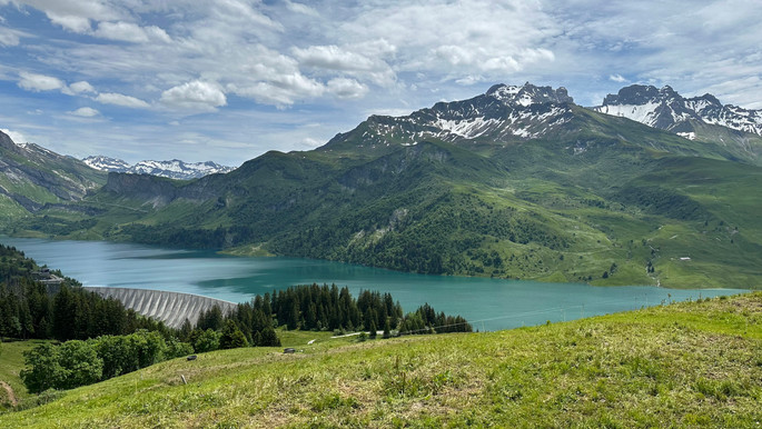
After seven weeks of non-stop riding (over 6,000 miles), Brian and I desperately needed some new rear tires. On our way out of Barcelonnette we spent the morning at a shop that told us some should be arriving that day, but when noon rolled around and there was still no sign of the delivery truck, we decided to hit the road to take advantage of the good weather. The route took us up and over some beautiful passes as we headed north toward Bourg-Saint-Maurice, France.


Other than learning the hard way that mountain tunnels between countries are crazy expensive (35 euro per bike to return to France after a short detour into Italy!), it was a great day of riding and we ended in the small town of Sangot.
We had heard from other riders about a few road closures due to landslides and construction, so the next morning we set off on an alternative route. The route turned out to be an off-road high mountain pass that made us wish we had our new rear tires, but the vistas were incredible.


We continued to wind our way through more beautiful scenery, stopping for lunch at a lake-side cafe, before riding up the Cormet de Roselend. We took some time to fly the drone and take in the surrounding scenery before making our way back to Sangot.


The following day was spent resting, working out, and planning for the upcoming days. We were looking forward to some non-bike activities and had heard wonderful things about the 10-day hut hike called the Tour du Mont Blanc, which crosses through France, Italy, and Switzerland on an epic circumnavigation through the mountains around Mont Blanc. The only problem was that most people plan their trips and book their hut accommodations six to eight months in advance and we were hoping to start hiking in two days (classic). Thanks to countless internet blogs and a very detailed Excel spreadsheet from our friends who had done the hike before, we were able to piece together four day hikes from two different campsites that would allow us to see some of the best sections of the trail.
Before that, however, we had another day of riding ahead of us! The next morning we managed to find a shop that could replace both of our rear tires, and then we headed up the highest paved pass in the Alps - the Col de l'Iseran. The scenery quickly transformed from lush green landscapes to vast white slopes with towering snowbanks as we made our way up the peak.


We continued north, passing over the Col du Petite St Bernard, on our way into Italy and to our gorgeous campsite in Courmayeur (European camping feels like cheating when you get fancy croissants and coffee every morning).


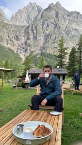


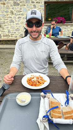
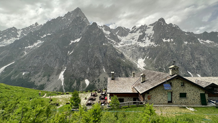
The next day we rode the bikes into town, parked them on the street, and started the long climb out of the valley for what is typically section five on the standard counterclockwise route of the TMB. Even with the gray skies, the views were breathtaking as we made our way past surreal mountain landscapes with massive glaciers. The route took us to Rifugio Bonatti, where we enjoyed a pasta lunch and some hot chocolate, before completing part of section six on our hike back down into the valley where we caught a free bus back to Courmayeur.


With heavy rain in the forecast, we decided to make the following day a rest day. As we watched the torrential downpour from the comfort of the campsite’s bar/cafe windows, we knew we made the right call.
Rejuvenated from the previous day’s rest, we awoke early the next morning to hike section four of the TMB in the less traditional clockwise direction. Fortunately or unfortunately (depending on whom you ask) we were a week too early to take one of the high-season cable cars, so we started the hike up from the valley floor right from our campsite. Once we cleared the treeline, the views were stunning. The contrast of colors from the ground to the sky made it hard to keep moving as we took countless photos and videos on our way to an off-route section our camping host had recommended. Sadly, the detour proved to be too snowy to be safe so we couldn’t make it all the way up the nearby peak, but it did make for some fun route-finding and snow crossings. We rejoined the normal route for the rest of the section and then hiked down into the valley to catch a bus back to our campsite.


All too soon, it was time to leave what had become one of our all-time favorite campsites. We crossed briefly into Switzerland over the Grand St Bernard pass (to avoid making the tunnel mistake twice) and stopped for a snack along the picturesque Lac de Champex.


We arrived at our campsite just outside of Chamonix, France and were treated to a beautiful sunset on the mountains as we had dinner at a nearby restaurant.


The following morning we rode the bikes into downtown Chamonix to catch the La Flégère cable car up to the start of the traditional final section of the TMB. Little did we know, however, the 42 km du Mont Blanc trail race was happening that day and went right along a large section of the TMB. After making friends with an Australian hiker and unsuccessfully attempting to find a detour around the race route, we set off down the trail taking turns calling out runners coming from behind as we quickly stepped off the trail to let them by. We were among many surprised hikers on the trail that day, but it was inspiring to see so many people completing this physical feat.


Eventually, the race route separated from ours and we continued up to one of the best restaurant lunch views we have ever had.

Although the mountain guides we spoke with earlier in the morning had failed to warn us about the race, they did tell us it was not recommended to attempt the final section of the day’s route which involved ladders and steep traverses due to excessive snow on the trail. We hiked as far up as we could before deciding to turn around and heed their advice. We took a different cable car down just in time to catch the award ceremony for the race.


For our last day of hiking in the region, we decided to do a popular trail on the other side of the valley from the TMB. We rode into town to catch the Aiguille du midi cable car, but learned that it is not like the other cable cars where you can just show up and walk on. The next ticket time wasn’t until 1:15 pm, so we decided to explore Chamonix. Chamonix is a very lively city equipped with every outdoor store imaginable, and we enjoyed people-watching and window shopping (it is probably for the best that we travel with such limited free space).
When our lift time arrived, we headed up to the start of the Grand Balcón Nord hike. The direction we went was mostly downhill (we accidentally started on the opposite end of what AllTrails showed), but it left us with plenty of energy to take in the views.


Although we could have easily spent a month in this region and been very content, we were happy with everything we had done and set off for Switzerland the following morning. We had plans to meet up with a friend near Interlaken in three days’ time and wanted to visit Zermatt along the way in hopes of summiting one of the glaciated 4,000 meter peaks near the famous Matterhorn.
Brian and I both have some mountaineering experience. We did guided summits of Cotopaxi Volcano in Ecuador and Pico de Orizaba in Mexico in previous years, and Brian completed a three-month long mountaineering course last year which included crevasse rescue and culminated in an unguided summit of Mount Rainier. Thus, we were looking for an objective we could do that would not require hiring a guide (but also wouldn’t kill us). After some research, we set our sights on Breithorn Mountain.
Since Zermatt does not allow any private vehicles to enter the city, we found a campsite just north in the town of Tasch (this was the eighth consecutive night of camping for anyone counting - Switzerland is expensive!). After setting up our tent, we took the 20 minute train ride into the city to find a gear rental shop. We had no issue acquiring the necessary boots, crampons, harnesses, and ice axes, but no shops had rope for rent (understandably - for most climbing you should only use a rope you know has not already taken a hard fall or sustained any damage). While weighing the merits of buying a rope for a one-time use or completing the climb untethered, we came across a used rope bin that was meant for recycling in a Mammut outdoor gear shop. One of the ropes in the bin, though clearly cut down from its original length, just so happened to be the exact length we needed and showed no obvious signs of damage. Though we would never consider using it for traditional rock climbing or a higher risk summit, it was good enough for our needs on this glacier and better than nothing. With all of our gear sorted, it was time to find some dinner.


We were hoping to find an affordable restaurant in town, but quickly learned they do not exist. Our best option seemed to be a very overpriced McDonald’s, but there was one catch - Brian was on a 19-year streak of not eating Mcdonald's (not for any particular reason other than to keep the streak going), but he decided this was a worthy occasion to call it quits. After spending 30 Swiss francs ($35) on two burgers and fries, we took the train back to our campsite to get some rest for the following day.

We awoke early the next morning to catch the first shuttle into town, get breakfast, and cue up for the series of cable cars that would take us to the start of the Breithorn glacier to begin our climb. The conditions were looking perfect as we took in our first views of the summit and the surrounding mountains.


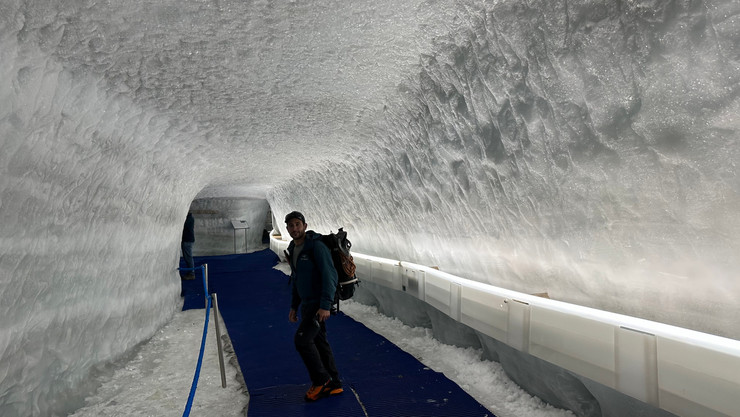
Once we arrived at the Matterhorn Glacier Paradise (the highest cable car station in Europe), we strapped on our crampons, roped up, and set off up the glacier. The route was very straightforward and we quickly found our stride, but a layer of clouds had rolled in obscuring the summit. We soon found ourselves surrounded by a sea of endless white. Unfortunately, the conditions continued to worsen, but we made it to the summit, walked the precariously narrow saddle ridge (see the last photo below for what it looks like when you are not inside a cloud), and made our way back down the mountain feeling accomplished.


What we saw on the ridge:

What the ridge looks like on a clear day (thanks to these strangers and a Google image search):

We took some time to explore the underground glacier palace full of natural crevasses and man-made ice sculptures before taking the cable car back down to Zermatt, returning our borrowed rope to the recycling bin, and catching the shuttle back to our campsite.


The following day took us over two of Switzerland’s most famous passes, Grimsel and Furka, on our way to Brienz, a lake-side town near Interlaken where we were meeting our good friend Tammy.


After nine straight nights of camping, we had booked a hotel overlooking the lake. Tammy, who was in nearby Geneva for a work conference, joined us that evening and we all caught up over dinner.

We had a lot of outdoor adventures planned for while Tammy was in town, however, the weather had other plans for us. It was forecasted to rain non-stop the following day, so we decided to have a relaxing day in Brienz. We walked along the lake admiring the many wood carvings and sculptures and having way too much fun with the interactive structures that were placed every 100 ft along the lake’s edge.


A local walking by felt the need to say: "those are fish, not boobs" and proceeded to keep walking his dog. It just might be our favorite quote of the trip.
Despite all of the rain, we were determined to do the hike we had planned for the following day. The hike is called Harder Ridge and many seasoned hikers say it is their favorite day hike and also the hardest day hike they have ever done. In addition, however, almost every trail review and AllTrails comment mentions something along the lines of “definitely don’t attempt this trail in the rain or right after it has rained,” but we were optimistic. One way to get to the start of the trail is to take a cog train up the side of the mountain. We booked the first train of the day and steamed up into the early morning mist.

The Harder Ridge is an unofficial trail (deemed too dangerous to promote as an official trail) that winds 14.5 miles along a ridgeline between Interlaken and Brienz with steep drop-offs on both sides for much of the trail. Our plan had been to hike to Interlaken and take the train back to Brienz, but about two minutes into the route, the slippery mud already clinging to our shoes had us questioning our plan.

We decided to hike as far as we all unanimously felt safe and to turn around as soon as anyone felt uncomfortable. Although we often had to look down at our feet, it was hard not to look up and take in the surrounding views as the clouds periodically parted to give us views of the bright blue lake and valleys below.


The trail conditions improved, but it was still slow-going as we made our way up and over the steep peaks. We knew we might end up hiking in the dark if we pushed on, so we took a bailout trail around mile four and did some route-finding through the brush to catch the cog train back down the mountain at a lower station. Although we were all bummed not to make it the whole way, we knew we had made the right call - especially as we watched some rain clouds roll in on our way down.
With our hike completed earlier than planned, we showered and took the train to Interlaken for the evening. We explored the bustling city streets, ate delicious Thai food, had drinks at a few local bars, and laughed so hard we cried.


The highlight of the night, however, came at the very end. As we were getting ready to head back to the hotel, we realized we had four minutes to get to the station or we would have to wait another hour for the next and last train of the night. We took off running down the street and it looked like we were going to make it, but just as we approached the tracks from the opposite side of our train, the crossing bars came down over the street (a minute early) impeding our path. Not willing to give up yet, Brian looked on his phone and saw there was a bus leaving in one minute that would get us to the next train station at the exact time the train we missed would be stopping there. We quickly ran to the bus as we watched our train roll out of the station. Two anxious minutes later, we arrived at the train station and saw a train on the farthest set of tracks. We sprinted across the station, down the stairs to the tunnel, and up the stairs to the last track like our lives depended on it. We catapulted ourselves through the doors and exchanged glorious high-fives as we reveled in our success. We sat down in our seats to catch our breath, but when the train still wasn’t moving two minutes later the high of our success started to fade. During our time in Switzerland, Brian and I had noted that Swiss public transportation tends to run a couple minutes early. We seemed to have forgotten this knowledge until that moment when it sunk in that the train we were sitting on was actually the wrong train. A quick google maps search showed us that our train had left the station early. Laughing at how comical and dramatic the last few minutes had been, we quickly disembarked the train in search of something to do for an hour.
Google wasn’t showing too many options, but just outside of the train station we saw a sign for a bar. As we followed the series of signs under the dimly lit train station into what appeared to be an office park, we were tempted to turn around. Just around the corner, however, we found Frankie’s.

After meeting Frankie himself, we learned that Frankie’s is a live music bar with frequent jam sessions during which anyone can play any of his instruments from the piano in the front to the trumpets hanging on the walls. We chatted with Frankie, laughed about the day’s events, and then caught the midnight train back to Brienz.


The next morning, we said goodbye to Tammy as she left for Geneva to catch her flight home and we hit the road north toward Zurich. We had plans to meet up with another dear friend, Sandra, who lives in the town of Fehraltorf just east of Zurich. We met Sandra in 2018 in Cusco on our South America motorcycle trip. She was riding her BMW F650 GS down the continent and we quickly became good friends. Although we rode together and hung out at numerous points along our route in South America, we hadn’t seen her since early 2019 and we were excited to catch up!
Her village was having an air show that weekend, so soon after hugging and saying our hellos, we walked to the nearby airfield to watch the planes soar overhead.


We spent the rest of the night chatting and catching up. The next day we went on a walk around a beautiful local lake and then took the train into Zurich for a lovely evening complete with delicious food and great conversation.


The following afternoon, we left Sandra's and headed back down south toward Andermatt to spend a couple of days riding the nearby roads. We went up two passes (Pragel and Klausen) and by the gorgeous Klöntalersee Lake on our way there.


We based ourselves just north of Andermatt and spent the next two days riding through the beautiful Swiss countryside on some incredible passes (Sustenhorn, Grimsel (again), Nufenen, and Gotthard).


I don't think these mountain views will ever get old.
Cheers,
Brian and Erin